
Showing posts with label maps. Show all posts
Showing posts with label maps. Show all posts
Monday, 5 January 2015
Ordnance Survey Maps - Six-inch England and Wales, 1842-1952

Thursday, 6 March 2014
Review: Prehistoric Wessex - Towards a Deep Map

Sunday, 12 January 2014
The making of Gosport Park
View Larger Map
I'm always fascinated by the landscape stories that it's possible to unearth using readily available sources. Yesterday a question was raised in the Gosport Memories group in Facebook about the origin of "The Dell", a recessed and banked oval of land in Gosport Park, Gosport, Hampshire (see Bing Maps).
With this kind of thing, it's always worth checking the excellent Old Maps map archive site, which readily finds that The Dell and the Park itself existed in 1898 ...
 |
| Gosport Park, 1898 OS map. Historic map data is (© and database right Crown copyright and Landmark Information Group Ltd. (All rights reserved 2009). Low-resolution image reproduced for small-scale non-profit use under the terms described in the Old Maps FAQ. |
 |
| Ewer Common, 1867-1881 OS map. Historic map data is (© and database right Crown copyright and Landmark Information Group Ltd. (All rights reserved 2009). Low-resolution image reproduced for small-scale non-profit use under the terms described in the Old Maps FAQ. |

A look in the British Library 19th Century Newspapers archive finds that the land was transformed in the late 1880s, the driver behind the project being Colonel Charles Mumby. See Charles Mumby & Co., Gosport and Portsmouth: Memories Evoked by the Isle of Wight Steam Railway for a good biographical summary. (He wasn't a 'real' colonel, by the way - this was the kind of era when the local bigwig automatically got parachuted into some medium-high rank in the regional volunteer battalion - roughly equivalent to the modern Territorial Army). An all-round Victorian entrepreneur who'd become rich chiefly from mineral water manufacturing in Gosport, he'd risen in the town hierarchy to become chairman of the Local Board (precursor to borough council), and one of his projects was the proposal in 1886 to develop Ewer Common as a public park.
The Chairman said that while at Ewer Common some time ago he thought that this large tract of land which measured nearly 30 acres, would form a very desirable place of public recreation. While paying a subsequent visit to London, he saw the Chief Clerk to the Secretary of the Ecclesiastical Commissioners. who were the Lords of the Manor at Alverstoke, and learned from him that no revenue was acquired from the land. He then wrote a letter to the Commissioners stating that the Common was merely used as a squatting place for gypsies and for digging gravel for the repair of roads, and that to his knowledge no common rights had been exercised for many years and he therefore asked whether the Commissioners would be willing to hand over the land for a public recreation ground. A favourable reply had been received, and he now moved that the question be referred to the Roads and Works Committee, for them to negotiate with the Ecclesiastical Commissioners with a view to acquiring Ewer Common.It seems fairly high-handed of Mumby to present the plan at such an advanced stage, and there were objections - particularly from a Mr Treacher, who argued that this, like a previous deal to acquire land for building Thorngate Hall, amounted to misrepresentation and fraud. (I assume his implication was that Mumby was exaggerating the worthlessness of the land in order to get the owners to relinquish it). However, the resolution was passed. Treacher's objections continued over the next few years - chiefly about the general expense and the legality of the funding process:
- The Hampshire Telegraph, February 13, 1886
Mr JF Treacher said that if he went according to his belief, he would oppose the motion [to borrow money to fence the park under construction] tooth and nail, but as the ground was commenced, he would remain neutral. He could hardly say that they had carried out this work in a strictly legal manner, as they had been drawing funds from the general district rate, for which no resolution had been passed. The total sum spent on Ewer Common would have been sufficient to build an Infection Diseases Hospital. Besides the Common was not in a central position, and would only be of use to a portion of the parish.The Park was completed in 1891, at a total cost of some £3000, and was opened on June 17th 1891.
- Hampshire Telegraph, May 16, 1891
OPENING OF THE GOSPORT PARKThe Dell, although not named as such in the account of the opening, is clearly the site of this egg-shaped track.
Wednesday was a red letter day in the history of Gosport. In magnificent weather the new Park at Alverstoke was formally opened to the public. … A piece of land that was useless, except as a camping-ground for gypsies, is now transformed into a well laid-out recreation ground, with a capital cycle track and running path. The track itself, which is about three laps to the mile, is egg-shaped, the curves making easy sweeps. An unsightly gravel pit has been turfed, and will make excellent courts for tennis, the sloping sides sheltering the players, and effectually keeping the balls from straying too far. A spacious carriage-drive runs round the whole ground, and altogether the Gosport Park is an ornament and a credit to the parish.
- Hampshire Telegraph, June 20, 1891
The Ewer Common peninsula has other historical interest as the site of the former Alverstoke House of Industry, one of the first radially-designed workhouses (hence the adjacent creek being called Workhouse Lake). You can see a detailed ground plan on Old Maps, which has a 1:500 town plan:
 |
| Alverstoke House of Industry, 1875-1880 town plan. Historic map data is (© and database right Crown copyright and Landmark Information Group Ltd. (All rights reserved 2009). Low-resolution image reproduced for small-scale non-profit use under the terms described in the Old Maps FAQ. |
- Ray (with thanks to Christopher Pope and Gary Baltao)
Monday, 16 July 2012
This goodly frame, the earth
 |
| Globus Biler globe, Silkeborg, Denmark image by Thomas Bredøl, reproduced under Creative Commons Attribution 2.5 Denmark license. |
On the subject of monumental constructions, I'm just in the process of purging my old blog, The Apothecary's Drawer, of posts that have succumbed to link rot, and rescued this.
This goodly frame, the earth
What's the world's biggest globe of the world? Depends what you mean. For sheer size, it's the Unisphere at Flushing Meadows-Corona Park, Queens, NY: "one of the few remaining artifacts from the 1964-65 New York World's Fair". Ingo Gunther's Exosphere sculpture (bigger images here) may be the largest suspended globe, although it's not representational. Another contender, which I don't know much about, is the Globus Biler (Globe Cars) globe pictured above; a converted gas tank at a car dealership in Silkeborg, Denmark. You might count buildings, such as the Ericsson Globe (formerly the Stockholm Globe Arena - billed as "the world's largest hemispherical building") or Mira on the Living Mall, Taipei, the largest spherical department store.

But if you bring in the proviso that it must turn and be a naturalistic representation of the world, since 1999 (when it was officially accepted by the Guiness Book of Records) it's been the 42-foot Eartha, the "World’s Largest Revolving / Rotating Globe" built by Maine mapmaking firm DeLorme (more on the background at PC World: Building the world's biggest globe).
This is unfortunate for Orfeo Bartolucci, the craftsman who constructed the previously largest revolving globe, as his story is in many ways the most interesting. He built the 33-foot "Mappamondo della Pace" ("Globe of Peace") over a period of six years near the small Italian town of Apecchio.
 |
| Mappamondo della Pace, Apechie, Italy Public domain image by "Wolfra", Italian Wikipedia |

I've taken the liberty of posting a translation, as best I can manage it, of the October 1999 news item by the Italian pipe manufacturers Centraltubi. It's a very nice and underpublicised story of a labour of love (or interesting obsession) that would be better known if it hadn't been done in rural Italy. (Translations that stumped me are in italics).
The largest globe of the world in the worldThe Massachusetts globe Mr Bartolucci refers to is probably the 30-foot stained-glass Mapparium in the Mary Baker Eddy Library for the Betterment of Humanity, Boston.
Apecchio is a small town in the interior of the Pesaro region. In its way, it's a capital, an important centre. It features in the Guinness Book of Records: it accommodates the largest globe of the world in the world. The statistics: 10 metres diameter, 30 cubic metres of wood, a ton of nails, 25 quintals of special putty [a quintal = 100 kg], 170 quintals in weight, room for 500 persons inside, and it's the result of six years of work by a single man: 75-year-old Orfeo Bartolucci.
Artificer, constructor, factotum, a man who loves impossible bets, he says: "How did the idea come to me to construct the greatest globe of the world in the world? I had the inspiration during a visit I made in the 70s with my sons to Venice. We were visiting the Ducal Palace with a guide who showed us through hall after hall. He explained the paintings to us. He told us the history. Until, our having seen a hall that was the largest in the world, he took us into a place where there was a globe of the world two metres in diameter. This astonished me more than many of the other things, and it remained impressed in my mind, the idea to construct one like it, and indeed larger.
"The plan began to nag at me constantly. Since a passion for carpentry, for hammering in nails, has always been much attached to my trade - as a mason, then a small building contractor - I thought I could do likewise with a sphere, and the idea began to mature of constructing one of 6 metres diameter. I wanted to make one that didn't exist elsewhere. For a little while I had doubts. If I constructed a 6-metre one, might there be another in the world of greater dimensions? I asked Mondadori of Verona if there were useful indications in the Guinness Book of Records that they publish. They answered that a globe of the world more than 8 metres existed in the United States, in Massachusetts. If I didn't make it larger, my project would be pointless. I determined to make it with a superior diameter of 10 metres.
"Alone, without saying anything to anybody, I set to work. By night I planned; by day I executed what I'd thought and worried about. I did this punctually from 5 in the morning until dusk, for six long years. For the enterprise, I relied on my pension and collected all my savings, taking care not to get into debt. From information I received from America, I knew that their 'stars and stripes' globe had been instigated by the editor of a major newspaper, in order then to donate it to the University. They were very kind, the Americans. They informed me that it had defects: a tendency to fall over, as it was constructed with materials with little resistance to bad weather. Moreover, in order to bring it to fruition would need an investment of well over half a billion [lire, presumably]. That information I used in the selection of my own materials".
But for Orfeo Bartolucci the globe of the world was not alone in his thoughts; there were also his ten sons who time after time told him they were starting a family. To all he has sbancato the land, in fact the foundations and many other habitations. From land acquired in the 70s, today [the site] has become like a village that joins to Colombara, the part of Apecchio where Bartolucci was born and where he means to remain as long as destiny wants. His story continues: "For this work I have received a tide of congratulations. Seven thousand onlookers and a representative of the State took part in the day of its inauguration".
Bartolucci in his special notebook has written other superlatives [of the project], large and small. He has constructed a miniature globe of the world 5 millimetres of diameter. Through a magnifying lens can be admired seas, gulfs, meridians and parallels. A micromotor and in grado di fargli to effect its beautiful daily revolution. On the titanium facade, the Marchigian has chiselled a 130-metre long rosary, with 59 beads of 80 centimetre diameter. The total weight: 300 quintals.
- Immagini Centraltubi newsletter,#15, October 1999. Author uncredited (see Internet Archive for Italian text)
- slightly edited version from The Apothecary's Drawer, 1st July 2004
When I wrote the blog post eight years ago, the Immagini Centraltubi article was about the only nontrivial online reference to the Mappamondo della Pace. I'm pleased to see, although Mr Bartolucci died in 2011, that it's getting a little more attention. This post at the blog Outsider Environments Europe, Orfeo Bartolucci, Mappamondo della pace/Globe of peace, is interesting in itself, but it links through to a good illustrated feature in Italian, Parco artistico: Orfeo Bartolucci (1924-2011), at the website Costruttori di Babele (Builders of Babel) - of which more later.
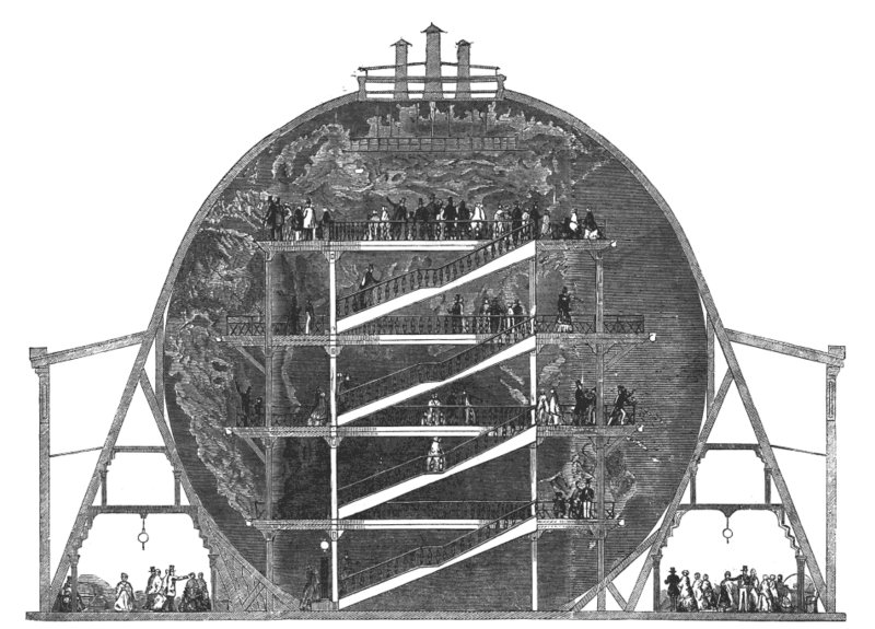 |
| Wylde's Great Globe - Illustrated London News 7 June, 1851 |
- Ray
Tuesday, 24 April 2012
Barchester

The series is based on the first two Barchester novels, The Warden (1855) and Barchester Towers (1857) which, you may or may not know, focus on an otherworldly clergyman, Septimus Harding, who is caught up in a newspaper-driven controversy over his occupation of a well-paid post of nominal responsibility, warden of the almshouse Hiram's Hospital. At first, Harding accepts the patronage of those helping him to stay in the post (and to reinstall him when it becomes vacant), but later he comes to question the ethics of the situation. The Victorian Web has a good appreciation and summary by Annalise K Walker of the full series: On Trollope's Barchester Series.
I had somewhat wondered where, if anywhere, Trollope's fictional "Barsetshire" is set. The Warden begins with a basic description ...
the cathedral town of ––––; let us call it Barchester. Were we to name Wells or Salisbury, Exeter, Hereford, or Gloucester, it might be presumed that something personal was intended; and as this tale will refer mainly to the cathedral dignitaries of the town in question, we are anxious that no personality may be suspected. Let us presume that Barchester is a quiet town in the West of England ...... but unlike Thomas Hardy, who interacted with readers and critics in mapping "Wessex" highly consistently on to real locations, Trollope didn't create a detailed geography at first, but sketched it out later as he wrote the 1860 Framley Parsonage. The paper Mapmaking in Barsetshire (Lance O. Tingay, The Trollopian, Vol. 3, No. 1 (Jun., 1948), pp. 19-32) mentions how this didn't come to light until 1927. Prior to this, enthusiasts had produced maps: the USA Trollope Society website has that painted by George F Muendel for Spencer Van Bokkelen Nichols (here), and another was produced by Monsignor Ronald Knox, who later wrote the 1935 novel Barsetshire Pilgrimage
Knox, initially working in 1922, showed that the books were inconsistent with Trollope's sketch, and even with each other. As Gillian Hill's 1978 Cartographical Curiosities (British Museum Publications) describes:
Trollope's Barsetshire, on the other hand, suffers from an excess of local topographical information. The general picture of the countryside is fairly clear, but contradictions abound in the detail. Ronald Knox brought these to light when he attempted to map the county in 1922, more than fifty years after the novels were written. At the beginning of the first of the Barsetshire novels, The Warden, the cathedral is at the west end of Barchester, but in the later novels it has moved eastwards, and stands by the London Road. Similarly, the distance between Barchester and Plumstead shrinks from nine miles in Barchester Towers to less than five in The Last Chronicle of Barset. The railway, too, has its idiosyncrasies: it passes within a mile and half of Courcy, which is a considerable way from its route.The Tingay paper mentions many more such cartographic problems. Later maps include Morris Weightman's map (here) for Angela Thirkell's 1930s Barsetshire novels. But inconsistencies apart, details such as train routes - eastward to Paddington, north-west to Bristol, and south-west to Exeter - plausibly put Barsetshire somewhere in the general area of the Wiltshire / Dorset boundary.

Trollope's own accounts of the inspiration also give geographical clues. The standard story in his Autobiography, as told in Trollope and the Close (Salisbury Cathedral Close Preservation Society, Annual Lecture - October 2006 - by Pamela Neville-Sington) was that it happened in Salisbury:
I had stood for an hour on the little bridge in Salisbury, and had made out to my own satisfaction the spot on which Hiram's hospital should stand.But he was also inconsistent on the matter, and in the last weeks of his life he told the historian EA Freeman that Barchester was based on Winchester (where he had attended school) and that Hiram's Hospital was based on St Cross. This is consistent with the chronology of a mid-Victorian scandal concerning Francis North (nepotistically appointed as Master of St Cross by his father, the Bishop of Winchester) misappropriating funds. However, it's by no means the only contemporary scandal. There's a very good analysis of the whole background in the notes to the Broadview Press edition of The Warden (Anthony Trollope, ed. Geoffrey Hardy, Broadview Press, 2011, ISBN 1551111381) - see, for example, "The origins of Barchester" (from page 9), "Trollope's comments on the genesis of The Warden" (from page 237), and "The major scandals alluded to in The Warden" (from page 247).
I mention all this background not out of viewing it as some definitive "meaning" to the novels, but out of the way it gives a handle of the social history of the period. Victorian England was a time of vast social change, and the conflict between the reforming and evangelical "low church" and the "high church" (the Anglican church run by a long-entrenched moneyed elite) was a major topic of debate, especially in the provinces.
In Exeter, for example, Henry Phillpotts (Bishop of Exeter, 1830 to 1869) was a classically controversial high church bishop who commanded a vast income by astutely gaming the preferment system. At a time when a grass-roots clergyman might earn £40 a year, he swung a non-residential canonry at Durham worth around £4000 a year in addition to the £3000 he earned as Bishop of Exeter, an appointment highly unpopular locally); this double income funded the building of his residence at Torquay (now the Palace Hotel). Niebuhr and Wilkinson's 1956 The Ministry in Historical Perspectives described him as one of the last of "a clerical aristocracy, who, whatever their origin, expected to live on a scale comparable to that of the nobility". He was satirized in the pseudonymous 1832 pamphlet Bishop Toby's Pilgrimage; Or, The Method of Procuring a Mitre., and gets a brief allusion in The Warden as Henry, one of the three sons of Dr Grantly.
Addendum. Small world. Angela at Literary Places just sent me the detail, from WHK Wright's West-Country Poets (page 167) that Bishop Henry was the great uncle of the writer Eden Phillpotts. I'd wondered if there was a connection, but was busy pursuing the Barchester thread.
- Ray
Tuesday, 28 June 2011
To Moretonhampstead and back

I photographed it while the bus was stopped on the way back from Moretonhampstead (we were visiting my mother-in-law in hospital there). The 45-minute bus trip from Exeter (the Country Bus 359) is worth doing, as it goes through remarkable countryside. First climbing from Exeter, through rolling foothills with deeply-cut valleys, as far as Dunsford, it then reaches a striking escarpment - see Geograph - when it crosses the River Teign at Steps Bridge, and continues to climb up one side of the wooded gorge of the Teign past an alpaca farm before dropping slightly to Moretonhampstead, which is in a kind of bowl-shaped plateau with views of Dartmoor's uplands beyond.
 |
| Devon. Digital Elevation Map Landmap Project via Internet Archive. |

As the DEM (left) shows, Devon is extremely hilly, with rapid elevation changes. The flood plain of the Exe (Exeter is the yellow dot) is about the only moderately large flat part of Devon.
- Ray
Thursday, 1 April 2010
The Reproach of Annesley

Like Dean Maitland, it's primarily an Isle of Wight novel written when Mary Tuttiett lived in Newport. Serialised in 1888/9 and published in 1889, it's a melodrama surrounding a romantic quadrangle - three rival suitors for one woman - taking place in the five years or so before 1871 (the date pinpointed by a reference in the final chapter to civil war in Paris, which would have to refer to the overthrow of the Paris Commune). The central location is "Arden" and its manor house and surroundings - highly recognisable as Arreton - with "Medington" (Newport) and its "Red House" also featuring. "Arden Cross" is Arreton Cross, and the Gales' inn "The Traveller's Rest" is the Hare and Hounds. I can't find the "Gledesworth" that's said to be over the downs from Arden; I suspect it's just derived from the author's middle name. A couple of segments, as with the finale of Dean Maitland, take place in Western Switzerland and the Jura Mountains; these undoubtedly draw on Mary Tuttiett's personal experience, as she mentioned in interview - see previously - having visited Yverdon-les-Bains before she became a permanent invalid.
I have to admit I enjoyed the book, probably because I'm getting attuned to the conventions of Maxwell Gray and/or the three-volume Victorian novel. As with The Silence of Dean Maitland and Unconfessed, the first third of the book is devoted to setting up the conflicts and characters before anything major happens; not knowing this, it could come across as a little slow. Probably the weakest point for me was the predictability of some plot points: from the moment Paul's body isn't found, you know he isn't dead; and when Edward sees the apparition of monk looking exactly like Paul, in the very region he disappeared, who else is it going to be? I'm even getting to like Maxwell Gray's detailed scenery descriptions: although she's very prone to pathetic fallacy, using sunsets and gloomy weather as an emotional soundtrack to the story, the best of them are photorealistic. Take the introduction, describing the road over Arden Down:
View Larger Map
Such scenes in Mary Tuttiett's books are clearly based on detailed personal observation, and she made the most of the few places she had been or could go (in later life when she was an invalid). This makes the books extremely interesting from a 'forensic' point of view; her biography isn't well-documented, but precise scenery provides good leads to where she had visited. On the other hand, it's painfully obvious when she gets out of her scope of knowledge. In The Reproach of Annesley, for instance, she seems to have little idea what a career soldier does; Edward appears to be permanently on leave.
The Reproach of Annesley was made into a movie in 1915 (see IMDb). The book itself is online at the Internet Archive (reproachannesle00tuttgoog: ignore the bad metadata saying it's only Volume 1).
PS Check out also the Arreton Blog.
The Reproach of Annesley is discussed in more detail in my book A Wren-like Note: the life and works of Maxwell Gray (Mary Gleed Tuttiett). See the official site, www.maxwellgray.co.uk
- Ray
The narrow, white high-road ran straight along the summit of the down; it was unfenced on one side where the turf sloped so abruptly towards a rich cultivated level as to make this almost invisible from the road, and on the other bounded by a bank, purple in summer with wild thyme, and crested by a high quiekset hedge, which effectually concealed the northem slope of the down and the wooded country beneath it spreading away to the sea. This thorn hedge, which, in default of leaves and blossoms, bore masses of thick and hoary lichen, instead of growing erect from its bank, running nearly east and west, was arched over to the north-east in an accurate curve, due to the fierce briny sweep of the prevailing winds, and was by the same agency smoothly shorn on the windward side. These strong salt winds, blowing off the sea and frequently rising to gales, give all the trees and hedges within their influence a marked family likeness, stunting their growth, and forcing them to bow to the north-east as if suddenly made rigid in the height of a south-west gale.The road is a metalled main road now, but the landscape is the same and you can even identify the rough location. Expand the Google Maps view below and have a look around.
But the salt south-west was silent on this cloudy March aftemoon, and in its place a bleak east wind, whirling the white dust from the flinty chalk road, and quieting gradually down as the sun drew nearer the west, was sweeping over the short turf with its low, lonely sound, which is half whistle and half moan. The rich level to the south of the down sprinkled though it was with occasional farms, each having its cluster of ricks and elm-trees, and varied here and there by a village spire rising from a little circle of thatched roofs, looked solitary beneath. the grey sky. It terminated on the east in some picturesquely broken hills, interrupted by a long, level grey band, which was the sea, and on the south in more hills of moderate height and irregular outline, which derived an unusual grandeur this afternoon from the deep purple shadows resting upon them, and emphasizing their contour against the silvery grey sky, a sky full of latent light. On the west again there were hills of gentler outline, beyond these little glimpses of piain and woodland, and on tbe faintest limit a curving break filled with a polished surface of sea, reflecting the dim yellow lustre of the declining sun, which glowed faintly through the curdling clouds above.
View Larger Map
Such scenes in Mary Tuttiett's books are clearly based on detailed personal observation, and she made the most of the few places she had been or could go (in later life when she was an invalid). This makes the books extremely interesting from a 'forensic' point of view; her biography isn't well-documented, but precise scenery provides good leads to where she had visited. On the other hand, it's painfully obvious when she gets out of her scope of knowledge. In The Reproach of Annesley, for instance, she seems to have little idea what a career soldier does; Edward appears to be permanently on leave.
The Reproach of Annesley was made into a movie in 1915 (see IMDb). The book itself is online at the Internet Archive (reproachannesle00tuttgoog: ignore the bad metadata saying it's only Volume 1).
PS Check out also the Arreton Blog.
The Reproach of Annesley is discussed in more detail in my book A Wren-like Note: the life and works of Maxwell Gray (Mary Gleed Tuttiett). See the official site, www.maxwellgray.co.uk
- Ray
Sunday, 14 March 2010
Street View
View Larger Map
Ooh, look: the bookshop where I work is on Google Maps Street View, which has just been updated to include Exeter. You can take a tour around Topsham if you like. I don't recall seeing the Google car, but looking at the orange window display with the Halloween pumpkins, the photo would have been around the end of October.
- Ray
Tuesday, 22 December 2009
Anachronistic map

I found a very nice little curiosity, the map of the Isle of Wight and Solent area pictured in part above:
Bacon's Large Scale Map, 1 Inch to 1 Mile . Fully Coloured . Index to Place Names . 20p
The curiosity aspect is the strange cartographic mix. The price obviously places it post-decimalisation (i.e. post-1971) and it features routes for the Isle of Wight car ferry and hovercraft ferries; yet much of the cartographic detail is pre-1850s. For instance, Gosport (above) is shown prior to much of its suburban development, as well as the building of its railway (disused by the 1970s, but the track still prominent) and the line of Palmerston forts from Stokes Bay to Elson, dating from the 1850s. The area of Newport, IoW, is likewise way out of date, showing an area between Newport and Carisbrooke called New Village that was completely swamped in the late 1800s surburban development of Newport. All the cartographers appear to have done is drawn modern ferry routes, red lines on roads, and a few location names (note the amateurish typeface on the "Harb." representing Portsmouth Harbour Station) on a map over a century old.
The makers of the map are credited as Johnston & Bacon (a division of Geoffrey Chapman Ltd), and a glance at Google shows Bacon's Large Scale Map of the Isle of Wight to have been in print at least as far back as 1900. I can imagine the financial motive in avoiding unnecessary revision, but I can't fully imagine what was going through their heads, cartographically and commercially, to carry on doing so well beyond the point of the map becoming weirdly and obviously inaccurate. Johnston and Bacon were absorbed into Bartholomew's shortly after: one might say not before time, if that was their idea of mapmaking.
I guess there's a lesson there in not believing historical data points without corroboration. he proverbial "New Zealander" finding this map in the ruins of London 500 years from now might well believe it to represent accurate geography.
PS: I just found at the Charles Close Society for the Study of Ordnance Survey Maps a paper, The rivals: notes on some intermediate-scale commercial topographic map series of Britain and Ireland since 1868, that bears out my impression of Johnston & Bacon. It says of G.W. Bacon & Co.:
This celebrated or (to collectors) notorious firm of map-publishers ... reissued OS mapping, photographically copied, and with some cosmetic alterations, notably added emphasis to railways and stations, rewriting of town names (often in bold lower case rather than the OS’s capitals) and colouring of main roads ... Perhaps the firm were enabled to ‘get away with it’ because they invariably used superseded OS mapping.
- Ray
Monday, 23 November 2009
Riddle of the sand

Straight Point, Devon: click to enlarge
Correlation of difference sources and media often produces intriguing stuff. I was just re-reading Notices of the Flowering Time and Localities of some Plants observed during an Excursion through a portion of South Devon, in June, 1851 (Edwin Lees, Esq. FLS, pp530-541, The Phytologist: a popular botanical miscellany, Volume 4, Part 2, J. Van Voorst, 1852). I'm not terribly bothered with botany. but the Worcester-based Lees (1800–1887) was staying in Exmouth, and so the paper includes nice accounts of excursions to areas I'm familiar with, such as the East Devon coastline between Exmouth and Budleigh. One of these is the promontory tipped by Straight Point, adjacent to Sandy Bay.
A long point of sandstone extends far into the sea between Budleigh Salterton and Exmouth, after passing the highest range of cliffs; and on either side of this were some singular, secluded, deep, gloomy dens, excavated by the sea, as if intended for the perpetration of deeds of darkness. On the western side of the point the sea had so broken down the sandstone rocks, that it seemed as if a huge quarry had been excavated there, such monstrous masses lay scattered about in all directions; the cliff itself shattered almost to fragments.It's still recognisable - see the image above of the western side and Sandy Bay - even if the general environment makes it less amenable to investigation: an army firing range on the promontory itself, and the huge Devon Cliffs Holiday Park on the adjoining land. That said, it's not at all a bad place to visit, with the coastal path taking you rapidly out of the developed area in either direction.
View Larger Map
While browsing the excellent Old Maps site, however, I did notice an interesting thing about Sandy Bay: it appears the name is new, and so is the sand. On the 1890 Ordnance Survey map, the bay is unnamed and has sand only at the cliff foot, with rocky shelving exposed at low tide. By 1933, however, it's called Sandy Bay on the map, and virtually all the shore at low tide is sand, as it is nowadays. I've no idea why, though studies show beach profiles to be very dynamic in this general area of coastline (see Holcombe to Straight Point (including Exe estuary), SCOPAC, 2004). See the images below, reproduced from Old Maps with kind permission.

A look in older literature confirms the name change at least. Pre-1900 Devon guidebooks - for instance, John Murray's A handbook for travellers in Devon - repeatedly mention Straight Point as a landmark, with no sign of "Sandy Bay", and the poet Patricia Beer's autobiographical Mrs Beer's House, in which she writes about her Exmouth childhood in the 1920s, confirms that "Sandy Bay" appears to be an early 20th century neologism.
We had a family routine of our own, which was to spend the afternoon at Straight Point. This was a beach about a mile along from Orcombe Point towards Budleigh Salterton. Considering its nearness to Exmouth, it was amazingly deserted: sometimes we were the only family there. It was not too easy to reach, however, and the path down from the cliff-top needed a fair amount of agility: there were no ropes or steps, and it was both slippery and steep. We always called it Straight Point, which was the name of the headland, but many people referred to it as Sandy Bay. I felt very strongly about this, after the age of ten, on what I thought were grounds of literary taste. 'Sandy Bay' seemed to me banal and pretty-pretty and feeble, whereas I felt that 'Straight Point' was decently and austerely descriptive (I hear it is now universally called Sandy Bay and that there is a caravan site on the cliff-top.)Things have certainly changed, with access to the bay by a concrete ramp. Another geographical feature at this location is mentioned in RF Delderfield's historical novel Farewell the Tranquil (a.k.a. Farewell the Tranquil Mind) in which he refers to the stream that runs southward (now through the Holiday Park) and enters the sea through the waterfall at Sandy Bay.
- Mrs Beer's House, Patricia Beer, Macmillan, 1968
The buildings stood on the crest of a gentle slope, about half a mile from the sea and the same distance from Littleham in the valley behind. To the east our land extended as far as a deep briar-grown streambed, (called a "goyle" in these parts) which carried all the springs and rivulets of the watershed to the sea, dropping some twenty feet over a low cliff to the beach at an outfall we called "Waterchute".Delderfield is evidently using a real local name, as it is confirmed in an account of lime burning in the district in Devon & Cornwall notes & queries ...
- Farewell the Tranquil Mind, RF Delderfield, 1950
There was a second Lime-Kiln at Straight Point, close to Water Shute, the barges discharging limestone on the beach in the same way as at Maer Bay.... and in a Trewman's Exeter Flying Post report (A sad drowning fatality at Littleham, Saturday, June 28, 1890) about the accidental drowning of a truanting child "between Straight Point and Water Shute". But unlike Sandy Bay, which has gained a name, the Water Shute appears to have lost its name entirely.
- Devon & Cornwall notes & queries, Volume 17, ed. John S. Amery, 1933
I am still, by the way, looking for the name (if any) of the chine above Littleham Cove, on the Sandy Bay side of West Down Beacon.
Addendum. Sand recommendations.
- Dune: if you haven't read it, do. Ignore the endless string of sequels.
- Ice-Cold in Alex: read the Christopher Landon book if you can find it. I only found out recently that it's strongly autobiographical.
- The Book of Sand: Borges.
- The Riddle of the Sands: Erskine Childers' classic. Despite the dated agenda, it's not at all bad as an early espionage novel, especially if you like sailing.
- George Sand.
- Sha Wujing
- Alum Bay: amazing scenery, despite the commercialisation.
- Marmotinto: see Benjamin Zobel and Andrew Clemens.
Wednesday, 28 October 2009
Rings of Saturn and other Litmaps
Folowing on from the Bruges-la-Morte post, I still haven't completely read WG Sebald's The Rings of Saturn (I came as close as I ever have to swearing in front of a customer a few weeks back when he bought the single copy I hadn't noticed was on the shelves). Meanwhile, there are continuing interesting posts at the blog Vertigo: Collecting & Reading W.G. Sebald.
I'm very much inspired by the possibilities suggested in Mapping Sebald's Literary Landscape, which links to Barbara Hui's "Litmap" - an annotation of Google Maps with the places mentioned during the East Anglian walking tour of the unnamed narrator of The Rings of Saturn.
See her Litmap Presentation Notes for background. The notes mention a similar project, Gutenkarte, that mines Project Gutenbeg texts to create presentations with placenames hyeprlinked to a map. It has rough edges - for instance, it thinks Providence might be a location in
but it seems a very good interface for reading works with a strongly geographical component.
- Ray
I'm very much inspired by the possibilities suggested in Mapping Sebald's Literary Landscape, which links to Barbara Hui's "Litmap" - an annotation of Google Maps with the places mentioned during the East Anglian walking tour of the unnamed narrator of The Rings of Saturn.
See her Litmap Presentation Notes for background. The notes mention a similar project, Gutenkarte, that mines Project Gutenbeg texts to create presentations with placenames hyeprlinked to a map. It has rough edges - for instance, it thinks Providence might be a location in
they had a notion that Providence would interfere in favour of him who was in the right.
- The Journal of a Tour to the Hebrides with Samuel Johnson, LL.D., James Boswell
but it seems a very good interface for reading works with a strongly geographical component.
- Ray
Thursday, 23 July 2009
More nice maps
Further to "A Buyers Guide to Maps of Antarctica", just a quick link (I'm quite busy helping set up the infrastructure for a music project): Cartophilia: Maps and Map Memorabilia. I particularly like the subcategory Maps as Art.
As explained in the post Empire: Striding Across Africa, Lord Salisbury was referring to the general British obsession at the time for gaining territory even if it made no strategic sense. He added:
- Ray
Stamps, postcards, advertising, coffee mugs, shirts, and other ephemera. I love maps, and maps as an element of design.
"I think that the constant study of maps is apt to disturb men's reasoning powers" -- Lord Salisbury
As explained in the post Empire: Striding Across Africa, Lord Salisbury was referring to the general British obsession at the time for gaining territory even if it made no strategic sense. He added:
Certainly the enthusiasm which has been evoked for this desolate corner of Africa has surprised me more than anything else in this controversy. We have had a fierce conflict over the possession of a lake whose name I am afraid I cannot pronounce correctly—I think it is Lake Ngami—our only difficulty being that we do not know where it is. We cannot determine its position within 100 miles, certainly not within 60 miles, and there are great doubts whether it is a lake at all, or only a bed of rushes.
- Hansard, 10 July 1890
- Ray
Thursday, 14 August 2008
Strange cartography
A while back - see Encyclopaedic thoughts - I mentioned a hostile post-WW1 personification of Germany in Cassell's Book of Knowledge:
This was just a textual description, but check out Dogs of War at BibliOdyssey for a series of actual satirical maps in this vein; the descriptions are so similar that I suspect that the writer of the Cassell's piece must have had such a map in mind. First the Cartoon, then the War: Europe in 1870 at Strange Maps gives the same treatment to the Franco-Prussian War.
Strange Maps has many more maps with various intents: politics, humour, fantasy, and so on. Skimming, highlights include the classic Charles Joseph Minard map ("The best statistical graphic ever drawn" - see also Revisions of Minard - a multimedia graphic of the harrowing outcome of Napoleon's 1861 march on Moscow); World Government Plan: Aliens to Police USA (a concept, not unlike that in Piers Anthony's SF novel Triple Detente, in which peace was maintained by swapping governments; London's Lost Rivers (one of my topics of interest - see Underground London); Holmes, Sweet Holmes: A Floorplan of 221B Baker Street; and Where On Earth Was Middle-earth? - UCLA geophysicist Peter Bird's mapping of Middle Earth on to European geography, apparently in the recent geological past with lower sea levels.
Oddments connected by theme: Map of Inland (post-apocalyptic Kent in Russell Hoban's Riddley Walker, from Riddley Walker Annotations); A Buyers Guide to Maps of Antarctica by Catherynne M. Valente, Clarkesworld, May 2005 (this is a story about the rivalry between two cartographers, one devoted to realism and accuracy, the other to creating fantastical maps).
Other previous map-related posts here: Hardy perennials; and Mountweazels and other fictions.
- Ray
the map of Germany was not unlike the picture of a stupid helmeted giant, sprawling on all-fours, with a pygmy master on top.
This was just a textual description, but check out Dogs of War at BibliOdyssey for a series of actual satirical maps in this vein; the descriptions are so similar that I suspect that the writer of the Cassell's piece must have had such a map in mind. First the Cartoon, then the War: Europe in 1870 at Strange Maps gives the same treatment to the Franco-Prussian War.
Strange Maps has many more maps with various intents: politics, humour, fantasy, and so on. Skimming, highlights include the classic Charles Joseph Minard map ("The best statistical graphic ever drawn" - see also Revisions of Minard - a multimedia graphic of the harrowing outcome of Napoleon's 1861 march on Moscow); World Government Plan: Aliens to Police USA (a concept, not unlike that in Piers Anthony's SF novel Triple Detente, in which peace was maintained by swapping governments; London's Lost Rivers (one of my topics of interest - see Underground London); Holmes, Sweet Holmes: A Floorplan of 221B Baker Street; and Where On Earth Was Middle-earth? - UCLA geophysicist Peter Bird's mapping of Middle Earth on to European geography, apparently in the recent geological past with lower sea levels.
Oddments connected by theme: Map of Inland (post-apocalyptic Kent in Russell Hoban's Riddley Walker, from Riddley Walker Annotations); A Buyers Guide to Maps of Antarctica by Catherynne M. Valente, Clarkesworld, May 2005 (this is a story about the rivalry between two cartographers, one devoted to realism and accuracy, the other to creating fantastical maps).
Other previous map-related posts here: Hardy perennials; and Mountweazels and other fictions.
- Ray
Thursday, 20 December 2007
Mountweazels and other fictions
A old article I just ran into in the New Yorker: Not a word, the interesting story of Lillian Virginia Mountweazel, an American fountain designer turned photographer who died prematurely in an explosion while on assignment for Combustibles magazine.
The interesting part is that she didn't exist, but appears in the 1975 New Columbia Encyclopedia as a copyright trap: if her biography turns up in any other reference work, the publishers will know that it has been stolen rather than independently researched. Another example cited is the appearance of a non-word, "esquivalience", in the New Oxford American Dictionary. It's nice to see this phenomenon confirmed, as it has rather an urban myth flavour to it.
As you can gather from the Wikipedia Mountweazel entry, fictitious entries have varied motives: copyright traps, plain mistakes, hoaxes for fun, and hoaxes for fraud. For instance, the 1880s American Appleton's Cyclopedia of American Biography has around 200 known hoax entries. In this case, the probable motivation was financial; the contributors being paid by space and with checking only for general style, the temptation must have been too great.
Similar considerations apply to maps. In 1999 this Telegraph article, AA in £20m battle over 'copied' Ordnance maps, reported how the Automobile Association was caught out as having copied from Ordnance Survey maps a number of deliberate stylistic fingerprints - "kinks in rivers, the addition of minor buildings or exaggerated curves in roads". You can find other examples at the OpenStreetMap article Copyright Easter Eggs - Maps that Lye, and confirm using Google Maps that there are definite discrepancies between the street data and aerial photos, such as The Avenue, Finchley, that's displaced to cut straight through a block of flats. As with textual references, it's a matter of opinion whether many of these are deliberately fake "trap streets", simple errata, or time-related errors (such as road layouts revised by subsequent building, or reliably anticipated ones that never came to be). - Ray
The interesting part is that she didn't exist, but appears in the 1975 New Columbia Encyclopedia as a copyright trap: if her biography turns up in any other reference work, the publishers will know that it has been stolen rather than independently researched. Another example cited is the appearance of a non-word, "esquivalience", in the New Oxford American Dictionary. It's nice to see this phenomenon confirmed, as it has rather an urban myth flavour to it.
As you can gather from the Wikipedia Mountweazel entry, fictitious entries have varied motives: copyright traps, plain mistakes, hoaxes for fun, and hoaxes for fraud. For instance, the 1880s American Appleton's Cyclopedia of American Biography has around 200 known hoax entries. In this case, the probable motivation was financial; the contributors being paid by space and with checking only for general style, the temptation must have been too great.
Similar considerations apply to maps. In 1999 this Telegraph article, AA in £20m battle over 'copied' Ordnance maps, reported how the Automobile Association was caught out as having copied from Ordnance Survey maps a number of deliberate stylistic fingerprints - "kinks in rivers, the addition of minor buildings or exaggerated curves in roads". You can find other examples at the OpenStreetMap article Copyright Easter Eggs - Maps that Lye, and confirm using Google Maps that there are definite discrepancies between the street data and aerial photos, such as The Avenue, Finchley, that's displaced to cut straight through a block of flats. As with textual references, it's a matter of opinion whether many of these are deliberately fake "trap streets", simple errata, or time-related errors (such as road layouts revised by subsequent building, or reliably anticipated ones that never came to be). - Ray
Thursday, 30 August 2007
Roads...
I'm constantly surprised at what Google is doing. If you haven't tried Google Earth, do, especially now that it has Google Sky. Meanwhile, Google Maps continues to increase coverage: Topsham now has high-res throughout. I see also from Google Blogoscoped that Google has begun, for some US locations, to add a Street View option where you can view locations from ground level (more systematically than the Ordnance Survey Geograph project - which is excellent but very much dependent on where the volunteer contributors felt was photogenic; see its Topsham coverage).
The idea of a ground level photographic map isnn't new: Blogoscoped has an interesting post, Photo-Auto Maps (1907), about a century-old Rand McNally travel guide with images to help drivers recognise important turns. The quoted poster, however, makes a slightly strange assumption that this idea was down to conventional road maps not having yet been developed. Road maps actually long pre-date cars. A few lovely examples: Paterson's British Itinerary, 1785, probably the first pocket-sized road map and gazetteer; the Gough Map, 1306, the oldest surviving road map specifically of Great Britain; and Peutinger's Tabula, aka Tabula Peutingeriana, a 12th century copy of a 4th century road map of the Roman Empire.
Here, at the University of Applied Sciences, Augsburg, is a full scan of the Peutinger map - and here's the British section. In the latter, there are signs of topographical and linguistic garbling: Dorchester isn't east of Southampton. You can identify the locations via the placename index at Thomas G. Ikins' Roman Map of Britain site. - Ray
The idea of a ground level photographic map isnn't new: Blogoscoped has an interesting post, Photo-Auto Maps (1907), about a century-old Rand McNally travel guide with images to help drivers recognise important turns. The quoted poster, however, makes a slightly strange assumption that this idea was down to conventional road maps not having yet been developed. Road maps actually long pre-date cars. A few lovely examples: Paterson's British Itinerary, 1785, probably the first pocket-sized road map and gazetteer; the Gough Map, 1306, the oldest surviving road map specifically of Great Britain; and Peutinger's Tabula, aka Tabula Peutingeriana, a 12th century copy of a 4th century road map of the Roman Empire.
Here, at the University of Applied Sciences, Augsburg, is a full scan of the Peutinger map - and here's the British section. In the latter, there are signs of topographical and linguistic garbling: Dorchester isn't east of Southampton. You can identify the locations via the placename index at Thomas G. Ikins' Roman Map of Britain site. - Ray
Subscribe to:
Posts (Atom)