Showing posts sorted by relevance for query blackgang. Sort by date Show all posts

Tuesday, 17 May 2011

IOW (3): Return to Blackgang

*
View Larger Map

... and so our walk ended at Blackgang. Near the southern tip of the Isle of Wight, the geology becomes more complicated, with higher cliffs and a succession of Upper Greensand rocks overlying soft clay.

Walking from Whale Chine toward Blackgang

The whole succession is easily eroded by streams, and two centuries ago Blackgang was the location of a "steep gaunt ravine", Blackgang Chine, which features in many contemporary prints. For instance, there's this image in George Brannon's 1840s Brannon's Picture of the Isle of Wight (The Expeditious Traveller's Index to Its Prominent Beauties & Objects of Interest. Compiled Especially with Reference to Those Numerous Visitors Who Can Spare but Two or Three Days to Make the Tour of the Island), and the excellent "Black Gang Chine, Isle of Wight" drawn and engraved by Charles Cousen, published in The History of Hampshire, 1869.

The Victorian entrepreneur Alexander Dabell saw the opportunity in 1842 and opened what was probably the first British theme park, charging an entrance fee to see the chine and the skeleton of a beached whale. The park still exists - see its website - with a continued succession of ownership by Dabell's descendants, and its entrance has long been guarded by a giant smuggler (below), alluding to the possibly exaggerated connection of the the chine with smuggling. Its flavour I recall from childhood was quaint and rather dry - there was a whale skeleton that formed the ceiling of the curio room, peepshow machines showing innocuous things such as the inside of an ants' nest, a wishing chair, a "electric shock chair" (I never had the nerve to try it, so have no idea if it genuinely shocked you or simulated it with vibration), and, chiefly, gardens and scenic paths. But over the latter part of the 20th century it has focused more on appeal to children with themed rides and entertainments. YouTube has some nice footage of the park approximately in the era I remember: 1960, 1965 and 1966

Entrance to Blackgang Chine theme park

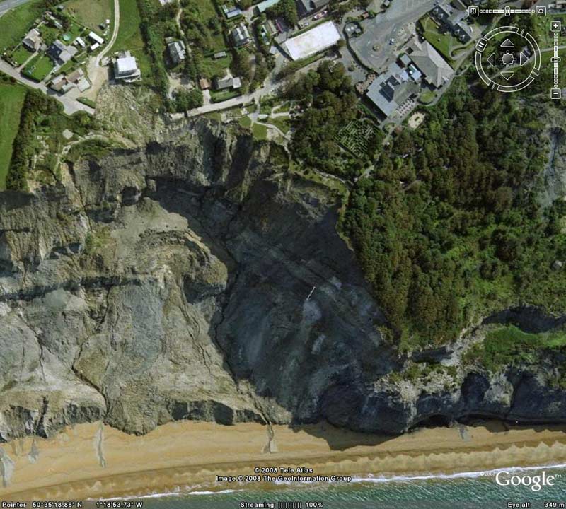
However, the geology - hard rock over soft clay - also means that Blackgang is an active landslip zone. Over two centuries, and particularly the 20th, the chine has eroded away entirely, as has a large portion of the adjacent land belonging to the park (see the Google Earth aerial view). The owners, understandably, have added a string to their bow with an inland park, Robin Hill, but have also incorporated the process of coastal destruction into their theme with a more adult-focused presentation, Blackgang: The Disappearing Village.  We didn't have time to go in, but made do with a restful moment feeding bread to the crows on the tearoom lawn.

One place I did want to explore was the east side of Blackgang, where a lane leads down from the theme park entrance. Originally this was a low-level route east, connecting with the "Sandrock Road" to Niton, but it was broken by a landslip in 1928. However, for many years after, the Blackgang end was largely intact, a track across a small landslip giving access to a section of road running through woods at the foot of Gore Cliff for half a mile or so. I just about remember this from childhood. But much of this section was obliterated in a major slip in 1978; there's a good map on page 191 of Slope stability engineering: developments and applications (1991), and the paper starting at page 189 - The recent history and geotechnics of landslides at Gore Cliff, Isle of Wight - is an interesting overall account.

The end of the road

It's very different now. The lane descends just a few hundred yards before narrowing to a path, still on overgrown tarmac, then the tarmac becomes cracked, and shortly you reach the cliff edge, with the last piece of road still showing its double yellow "no parking" lines. There is a rough footpath leading on over the slipped rock into a typical jumbled and overgrown undercliff landslip; unfortunately we didn't have time to explore further. I've seen undercliff areas before, but I found it quite chilling to see such literal erasure of a whole landscape I remember.

Gore Cliff and the Blackgang Undercliff

An intriguing aspect is that if you look at Google Maps (here) you can see that within the disrupted landscape of the Blackgang Undercliff, beyond the 1978 slip, there's an isolated section of woodland with the road intact, and signs of buildings and caravans. Time apart, we weren't kitted out to cross the landslip and investigate, but a number of explorers have done so, and documented it on YouTube (it reminds me of Pripyat). There are a number of unusual points, particularly the Shakespeare Fountain, which was in the grounds of Southview House - the nearby temple is gone; and the remains of a nudist holiday camp, The South View Sun Club, with quaint murals. See Blackgang Chine abandoned village & landslip exploration; Blackgang Chine,The Lost Village, I.O.W; and Walking over the lost Blackgang Road, Niton Undercliff, IoW, July 2006 (below).


Note: this post is an update to The disappearing Chine, August 2008.

Addendum: I've mentioned Mimi Khalvati's poem The Chine a couple of times. Sorry to mention it again, but every time I read it I find more layers; it encapsulates so powerfully the "double exposure" experience of returning to a place changed by time, and all the more so for being the same kind of place that's in my own early memories. It's online in full here (scroll down - it's below the French translation) at Poezibao, Florence Trocmé's online poetry journal.

Addendum 2: At the end of October 2011, I revisited the Blackgang again, and did the walk into the Undercliff - see On the lost road.

- Ray

Tuesday, 7 April 2015

Blackgang Chine, March 2015

Finally, after years of visiting the Isle of Wight, and many walks starting or finishing at the Blackgang Chine bus stop by the giant smuggler, we visited the Blackgang Chine theme park itself. And an interesting visit it turned out to be ...

Wednesday, 13 May 2015

Isle of Wight: index

In parallel with the Devon history subject list, here's another for the currently some 140 Isle of Wight posts on JSBlog. Like the Devon posts, they're a mix of walk photos, galleries from out-of-print travelogues, looks at at old novels, and a good number of detailed explorations of Isle of Wight historical and topographical subjects.

Sunday, 1 December 2013

Nooks and crannies - an ill-fated housing boom

click to enlarge
This is the cover of a pleasant booklet, Isle of Wight: Forty-one camera studies of the nooks & crannies, bays & chines of the garden isle, produced by the Photochrom Company of London and Tunbridge Wells. It's undated, but circa 1910. The cover has a cut-out revealing the first image, a location that's one of my obsessions, Blackgang Chine, a now-destroyed coastal ravine near the southern tip of the Island.

click to enlarge
The image, taken from the headland called Blackgang Bluff, looks across the chine to various clifftop villas in the near distance, part of the mid-Victorian development of Blackgang, and off into the distance over the 'Back of the Wight'. The row of houses at the right is called Cliff Terrace, which is presumably the "terrace of lodging-houses" described in Edmund Venables' 1867 A guide to the Undercliff of the Isle of Wight, Shanklin and Blackgang (page 67). There were further villas at Lowcliff, hidden by the cliffs at the right of the photo - compare the view I posted a while back:

Low-resolution image reproduced in accordance with dissemination statement: McInnes, R. 2008. Art as a tool in support of the understanding of coastal change. The Crown Estate, 106 pages, ISBN: 978-1-906410-08-7 First published 2008. Click to enlarge
click to enlarge
All of the cliffscape in the foreground has been destroyed by coastal erosion over the 20th century. Cliff Terrace itself has been truncated, and is one of the few remnants of a fairly ill-fated Victorian development boom.

Apart from finding the picture interesting, I returned to the topic because I hadn't fully realised the extent of the speculative developments and land dealings going on in the Isle of Wight in the 1830s-40s. I already mentioned the land turnover at Bonchurch in that period, associated with the breakup of the manorial estate - see Brannon on Bonchurch and ... in the Isle of Wight #1. Similar moves happened with the breakup of the "Buddle estate" near Niton; an advertisement in the Hampshire Telegraph and Sussex Chronicle for September 11, 1847 offers the individual sale of a portfolio of plots "with an extensive frontage to the Coast, affording a grand sea view, and admirably adated for the erection of Marine Villas".

The Newport agent managing the sale, Mr Francis Pittis (later Sir Francis Pittis, mayor of Newport), must have done extremely well out of such deals, because the same issue shows him handling the sale of recently-built properties at or near Blackgang: the "Italian style" South View House (previously mentioned here); the "Gothic villa residence" Lowcliff Lodge (the large house at bottom right of the colour image above) and Lowcliff Cottage at its drive entrance. Around the same time (Hampshire Advertiser & Salisbury Guardian, October 16, 1847) he handled the sale of the estate of James Barlow Hoy, whose 38 lots included pasture land and houses in the area of Blackgang and Chale; and in the Hampshire Advertiser & Salisbury Guardian of May 19, 1849 he has further ads for the recently-built Southlands (with "15 acres of pasture land, part of which is composed in terrace walks, pleasure grounds, and gardens, and includes the most valuable and desirable building sites") as well as the Blackgang Hotel itself (now part of the offices of the Blackgang Chine amusement park), Blackgang Farm, and various nearby properties.

The whole development, looking in hindsight, seems wildly shortsighted. Even then, the land was known to be unstable, with a particular major slip in 1799 taking out 100 acres and Pitlands Farm at Blackgang. Only a few years before the boom, the author Robert Mudie, in his The Isle of Wight: its past and present condition, and future prospects (c. 1840) commented extensively on the 1799 slip, and the high probability of future ones - see page 100 onward - saying that
the fate of this [farm] however ought to give some warning to those who are erecting villas between the land-slip and the chine; for, though these may be founded immediately on the rock, and that rock may have the appearance of stability. appearances in such a place are not to be depended upon; and it is very possible that the leveling of a flat area for a villa and its patch of lawn, may tend to admit the water in the vertical fissures and cutters of the rock, and thus hasten some such catastrophe as that to which we are alluding.
Mudie was right, but it all took longer than he feared. As it happened, none of the affluent buyers ever fell off a cliff while in occupancy; the larger villas outlived the era of the gentleman mansion owner, and generally succumbed quietly to property blight and dereliction / demolition long before the cliff reached them. Southview, for instance, suffered minor damage from the 1978 landslip, and was destroyed by fire (how it started appears unknown) shortly after. There don't seem to be any easily findable records of what happened to Southlands or Lowcliff. But one notable villa from this era, Five Rocks, is still extant, and houses the goblin-haunted "Rumpus Mansion", one of the theme park features.

The Carisbrooke Castle HistoricImages site has some very impressive views of Blackgang in the early 1900s (you can see higher resolution if you select an image, right-click, and view it in Windows Photo Viewer; from the terms of use, this seems to be OK as long as you don't use them for anything). This one in particular - #1766 - also shows Cliff Terrace and Lowecliffe, with other buildings in positively scary locations at the foot of the chine.

Update, 1 Nov 2014
I've found a deal more about Lowcliffe and Southlands: see Lowcliffe and Southlands: from cradle to grave.

- Ray

Thursday, 4 June 2015

The Reades' ministry: Blackgang and Punrooty

Another Blackgang, Isle of Wight, story: "Mr. Charles Reid, at Blackgang, in the Isle of Wight, is indefatigable in calling the sinner to sobriety.” notes the author of Drink: the Vice and the Disease, in the October 1875 London Quarterly Review. This one-liner spins off into an unusual saga of 19th century missionary activity by unlikely people in unlikely places.

Monday, 31 October 2011

On the lost road

15 - Shakespeare Memorial Fountain
There's a better photo, not by me, at Flickr.
I've mentioned in a couple of previous posts - see particularly IOW (3): Return to Blackgang - the "lost road" at the southern tip of the Isle of Wight. This is in the Blackgang landslip complex, where a section of the former road between Blackgang and Niton remains isolated, cut off at each end by major slips (see Google Maps, and for technical details, see page 191, Slope Stability Engineering: Developments and Applications, 1991).

I've been intrigued by it for a while - actually quite obsessed with the prospect of going there - and finally visited it on Saturday. It's completely inaccessible from the Niton end, where Sandrock Road from Niton ends at a sheer cliff above a mess of overgrown landslip (see Google Maps view). But from the Blackgang end, at the end of the truncated road is an established path over the landslip; the problem, however - I'd been warned from reading online discussions of the place - is that this path runs close to the cliff edge. That proved to be an understatement: coastal erosion has proceeded to the point where there are now two short sections where the path is about a foot away from an unstable cliff edge over a drop of some 300 feet to the beach (undergrowth and general terrain stop you taking any alternate route further from the edge). I'm pretty good with heights as such, but it certainly scared me; Clare, very sensibly, stayed behind to raise the alarm if I didn't come back.

Once over the scary section, there's a lot to enjoy about the walk, which is somewhere between country ramble and urban exploration. The landscape is classic undercliff: an overgrown tumbled terrain on a clifftop ledge backed by further, higher, cliffs. There are superb views of the landslip and the 550-foot Gore Cliff above, and (the visibility was good) along the coast to the Tennyson Down and the Needles, and  even across to Old Harry Rocks on the mainland. The road - some quarter of a mile of it exists - is now extensively overgrown, having shrunk to a single tarmac path. But in places, it's still recognisable as a tree-lined country lane flanked by stone walls, and in one of these walls is the now-dry Shakespeare Memorial Fountain with its text "TAR AND THE RO" (the remnant of the logo "The water nectar, and the rocks pure gold" from Two Gentlemen of Verona, Act 2, Scene 4).

I admit I found visiting the remains of this fountain, which I remember from my childhood, a powerful experience. I've since had a tattoo of it as a memento: see "Ursula" and Blackgang.


There are still buildings, too, though considerably more overgrown and run-down than in recent accounts; for instance, of a pair of caravans that was there until not long ago (and visible on Google Maps), one has gone entirely and the other has been vandalised. Being by myself, for safety's sake I didn't venture much off the road, but it was possible to see from it the huts of the defunct nudist holiday camp, the South View Sun Club; and at one point the road is crossed by water and power cables leading to an two-storey house some way below - I've since found out that this is the coach house of Southview House, the old home of Thomas Letts - where I could see someone working. I didn't investigate that (a YouTube comment suggested the owner, having had tools stolen, doesn't welcome explorers). I didn't see or meet anyone else on the road.

(Addendum: the house has since been destroyed by fire - see Southview goes west).

It was, overall, a fascinating and probably unique place, at least in England. (While the Lyme Regis - Axton and Hooken undercliffs have similar terrain, those slips are much older and don't intersect roads and recent habitation).

We didn't actually notice, until walking back out, the Isle of Wight Council sign, on a footbridge way above normal viewing height, saying "Danger. No public access. Active landslide. Keep out". That's an accurate description and warning. The access path is genuinely scary and dangerous; and I don't say that as a teaser, boast or challenge. It just is. If you really must go there, don't go alone; and don't try it if you're not very sure on your feet or get very jittery about heights. And even with all possible precautions, the cliff edge is unstable and could well choose to collapse as you're crossing it; in fact the whole landscape is on borrowed time. I had a tense walking-on-eggshells sensation all the time I was there.

In fact, although I've done far more strenuous and objectively dangerous walks, I found this the most intense experience of landscape I've had for decades - the more so for the powerful 'double exposure' sensation of finding a place I just about recall from childhood preserved in post-apocalyptic isolation only a few hundred yards from the mundane world of tea-shops and bus routes.

There's a YouTube video of the walk (not by me) taken five years ago: Walking over the lost Blackgang Road. The creator omits the scary bit.

Addendum: "Stef" kindly sent me a link to an archived ITN report - Shotlist Ref: BSP130194015, 13th January 1994 - of the last major slip in 1994. At 2:03 you can see the hut dwelling in image 10 below.

Addendum 4 May 2014: Chris Bedford sent me a link to his website Dumpman Films, which offers a large selection of videos of out-of-the-way and abandoned places. "Abandoned railways/disused railways feature heavily; what magic there is in seeing an abandoned railway station or tunnel or other such relic left behind as a result of Dr Beeching's axe. However, wartime bunkers, sewers, canal tunnels, collapsing piers, disused industrial sites, old roads and ruined Victorian asylums crop up too." It has links through to many other interesting sites.

- Ray

Here's a gallery of Saturday's expedition (click any image to enlarge):

1 - Blackgang landslip from NW

2 - looking NW from landslip

3 - Gore Cliff

4 - Gore Cliff

5 - the road acquired

6 - vandalised caravan

7 - on the road

8 - on the road

9 - on the road

10 - a hut dwelling

11 - the abandoned nudist site

12 - looking SE, end of road

13 - slip at Niton end

14 - slip at Niton end

15 - "TAR AND THE RO"

16 - looking NW from slip

17 - the drop!

18 - Gore Cliff

19 - Gore Cliff

20 - the warning!

Update, March 2015 We visited Blackgang Chine recently - see Blackgang Chine, March 2015 (which links to some new posts related to the Chine) - and I can confirm what I've seen mentioned in forum discussions: the Blackgang end has now been comprehensively fenced off (whether by the Council or the Chine management I don't know). Apparently this is because the unofficial footpath has now fallen away, which is unsurprising, considering it was only a few inches from the cliff edge in 2011. I don't know if there's any access from the Windy Corner end.

2015: Blackgang end fenced off
- Ray

Saturday, 25 April 2015

Blackgang: Five Rocks

"Here once was a fine house
Spacious, warm and bright.
Where the island’s lords and ladies
Danced all thro’ the night.
But then the boggarts and the brownies
And elves, in they came.
Took over the mansion
Now things aren’t the same.
It’s dark and it’s gloomy.
The humans have fled.
It’s a fine house no longer.
It’s Rumpus instead!"
- cited from transcript at jbonline.org.uk/blackgangchine

Friday, 31 October 2014

Lowcliffe and Southlands: from cradle to grave

I've touched on this topic a couple of times before, but I just found in Isle of Wight County Press Archive an editorial that's quite enlightening about the fate of Lowcliff (aka Lowcliffe aka Lowecliffe) and Southlands, two villas built in the 1800s on the unstable cliff terraces near Blackgang, Isle of Wight.

Tuesday, 5 August 2008

The disappearing Chine

I like the way that, increasingly, online availability of old texts makes it possible to dig into history. I was just looking again at George Brannon's 1840s Brannon's Picture of the Isle of Wight (The Expeditious Traveller's Index to Its Prominent Beauties & Objects of Interest. Compiled Especially with Reference to Those Numerous Visitors Who Can Spare but Two or Three Days to Make the Tour of the Island). Perhaps the remarkable thing is that some things haven't changed much in nearly two centuries, but some have, such as the striking "gloomy chasm" of Blackgang Chine ("chine" being a regional name for a deep-cut seaside ravine).

Blackgang Chine you may know to be long-running Isle of Wight coastal amusement park. It was established by Victorian entrepeneur Alexander Dabell, who saw a triple opportunity in the "steep gaunt ravine", the popularity of a nearby chalybeate spring and the skeleton of a beached whale to exhibit, and set up what was probably the first British theme park. Blackgang Chine was first documented in the 1700s. While writing another article a while back, I asked the current owner, Simon Dabell, about its history; he told me that it was "a visited geographical location for at least 100 years before his great-great-grandfather opened the gorge as an attraction in 1842/3" (there are early engravings dated around the 1760s). "However the island was rarely visited by non residents before the 1750s so the mists of time cover any earlier knowledge of the site".

The Chine features in many paintings and prints of the 19th century. This 1816 Peter de Wint print, Black Gang Chine and these images from the 1834/1845 Barber's Picturesque Illustrations of the Isle of Wight, show the waterfall at its foot; and there are various offshore views: the 1837 Brannon print at the NMM showing the wreck of the Clarendon at its foot, and this scene by Charles Cousen, published in The History of Hampshire, 1869. Queen Victoria and Prince Albert visited in 1843, many Victorian travel guides and accounts mentioned it; it inspired poetry;

Far to southward of Thule's island, by the craggy shores of Wight
Wild and drear, and very lonely, falling on the stranger' sight,
Frowns in all its primal grandeur, like an earth-discovered mine,
What, from ages immemorial, ancient men have called the Chine.

... etc

Black-Gang Chine, J. Albert Way, The Ladies' Companion, Bradbury and Evans, February 1855 - Google Books

and it even turned up in novels, such as Captain Marryat's 1837 Snarleyyow - Or, The Dog Fiend (see the description in Chapter XVI) and Charlotte Mary Yonge's 1889 A Reputed Changeling. Both involve smugglers, and the latter literally features a Black Gang operating there, fostering an apocryphal smuggling etymology (in fact, although undoubtedly smuggling went on, "Blackgang" just means "black way").

However, chines, on a geological time scale, are ephemeral features. They're formed by a nicety of circumstance - seaside stream, soft-rock geology, and ongoing cliff recession - which stimulates rapid erosion. Blackgang has the added factor of being at the end of the Isle of Wight Undercliff, an active landslip zone, which made it ephemeral even on a historical time scale, The landscape had long been known to be fluid. Marryat's Snarleyyow describes the area in 1699, saying that "since that period much of the cliff has fallen down, and the aspect is much changed", and Black's Guide said in 1870: "A fearful fall occurred in February 1799, when a farm near Niton, called Pitlands, and about 100 acres of land, were rent to pieces at one sudden catastrophe. At east end, in 1810, 30 acres were uptorn in a similar manner, and 50 acres in 1818".

The 1869 Charles Cousen print is probable the nearest thing we'll get to a mid-19th century photorealistic image where you can actually identify the geology: the lower brown section of Lower Greensand, with a white topping of what appears to be Upper Greensand Chert Beds or even Chalk, which made this an unusually complete section mentioned in geological texts such as Conybeare & Phillips' 1822 Outlines of the Geology of England and Wales, with an Introductory Compendium of the General Principles of that Science (see Google Books). However, erosive change began to be very evident by the late 1800s, when a lower-level road was carried away. The Chine was still an accessible and impressive, if rather softer-looking, ravine as shown in this 1890 photochrome and early 1900s postcards at Bartie's website. But the process went on over the 20th century, as shown in these postcards from shalfleet.net. At some point the capping was lost (the Chert Beds are still visible in Gore Cliff behind the amusement park) and the ravine became progressively blunted until now there's just a broad concave area of landslip (see this aerial image at Phil Brace's Isle of Wight Gallery).

The Blackgang Chine amusement park is still hanging in there, though forced to constantly adapt to the changing cliffscape - see Isle of Wight Nostalgia - Blackgang Chine Theme Park - The battle against erosion. I was pleasantly surprised to see, even though the park's theme has drifted from eccentrically genteel to child-orientated, the whale skeleton and Wishing Chair (that I remember as a child, my family being from the Isle of Wight) are still there. Perhaps that explains my abiding interest in this place: this piece of landscape progressively fraying away is a very literal metaphor for the departure of the past into memory, rather like Stephen King's 'Langoliers' that devour the fabric of the past or "the mechanism" in William Gibson's Agrippa (of which more later).

Other chines, however, still exist, and are strangely varied for such small geographical features. My favourites on the Island are Shanklin Chine and Whale Chine, both of which are considerably more stable features as they're outside the Undercliff landslip. The first - see the official site - is a cosy wooded place with waterfalls that has charmed visitors for at least two centuries, and hasn't radically changed over that time, as Brannon prints and later postcards show. The second, in contrast, is stark and weird, almost Martian in appearance - see this and other images at Geograph.

See also: The Silence of Dean Maitland.

Addendum: see the 2011 update, IOW (3): Return to Blackgang.

- Ray

Wednesday, 8 April 2015

Blackgang: a whale of a chine

There aren't many roles for whale skeletons in literature, but one appears in Maxwell Gray's 1913 novel Something Afar (published in the USA as The Desire of the Moth), where the author gets in a reference to her native Isle of Wight and a description (fancifully embroidered by Blanche, the protagonist's wife) of the celebrated whale skeleton at Blackgang Chine.

Tuesday, 12 June 2012

The road more travelled ...


View Larger Map

At the risk of boring you with endless pictures of woodlands and cliffs - skip if you've already reached saturation - I have some photos from May 26th, a windy and majorly hot day when we took the fairly short walk from Niton to Blackgang, at the southern tip of the Isle of Wight. The interesting point is that this route follows the accessible end of the old coastal road between them, which was cut by a landslip in 1928 - the other end is the "Lost Road" I described previously - and goes up over the spectacular Gore Cliff above the landslip.


View Larger Map

You start by following the main road southward from Niton that descends Barrack Shute - alternatively the Southern Vectis "6" bus will drop you at the foot of it. Then you turn off the main road down a lane running south-west - Sandrock Road - which in turn has a branch prominently signposted Old Blackgang Road. Follow this through the woodland until it just ... stops.


At first it's densely wooded on both sides, but then opens out to give views of the wooded slopes on the landward side, and rolling open pasture on the seaward. There are gates with paths to this pasture, which you might want to follow; because the lane is leading to a viewpoint and parking spot at the end, there is a certain amount of traffic on the road.


And at the end is the location called Windy Corner, with this spectacular view.


The chalk cliffs in the distance are those of Tennyson Down, at the western tip of the Island.
Panorama - sorry, I clipped the top of the cliff
The cliff, capped by overhanging crags of chert-studded Greensand, is called Gore Cliff.  The overgrown slopes are the Undercliff landslip terrain; and the large arc in the cliff, and the ridge of rubble below, are the scene of the 1928 slip that disrupted the road through what is now a wilderness. The isolated segment of road - also disconnected at the other end - is somewhere in all that woodland ahead. And bear in mind that this is on the Undercliff: a ledge some 300 feet above sea level, with Gore Cliff maybe 200 feet more above.


The path down to the beach: that tiny thing mid-picture is a stile.

This pastureland, although still a consequence of landslips, is a very gentle contrast to the overgrown tangle immediately adjacent. We didn't go to the beach; it was so hot that 300 feet down and up didn't appeal (apart from which, it's a naturist beach and the etiquette would undoubtedly get complicated).

Looking down the overgrown landslip to the beach

Gore Cliff at Windy Corner
Instead, we returned along the road part of the way, and around 300 metres along, there's a signpost for a path leading to steps up the cliff.

Old Blackgang Road, looking east

Below, an image from 2011 of the "Lost Road": the section of this very same road in the section near Blackgang isolated by landslips decades ago and only travelled by determined walkers. It's quite a striking contrast as the 'post-apocalyptic twin' of the photo above.
Old Blackgang Road - "Lost Road" section - looking east


Part-way up was this stone basin and tunnel; I don't know what these are about. The steps carry on up the cliffside until you're high above the Undercliff and you can see St Catherine's Point lighthouse.


St Catherine's Point lighthouse and Knowles Farm

Looking along the brink of Gore Cliff

Looking down to the Windy Corner car park
It was stunning, if a little frightening in the stiff wind, at the top of Gore Cliff. The path runs approximately westward, with sheer drop to the left and the St Catherine's Oratory lighthouse ( the "Pepperpot" - the scene of Emma MacAllan's The Children of St Catherine's Chantry) up on the hill to the right.


Shortly after, you see the buildings of Blackgang Chine amusement park, and the vista across the whole "Back of the Wight". The path then descends via more steps to the car park and Chine entrance with its well-known giant smuggler.

- Ray